Ben Calton, Head of the Centre for Geospatial Applications at PML Applications, shares an exciting development for our Earth observation data platform, CORDIAL, designed to enable better access and visualisation of Earth observation data. The tool is now available to a range of commercial sectors with flexible and easy-to-use custom-built packages.
Providing users with access to easily readable data in a format that is tailored to individual businesses’ needs, it has already seen success when trialled within the environmental and defence sectors. Now it is ready to be adapted for a range of businesses under the name CORDIAL (Central Open Repository for Data, Information, Analysis and Learning).
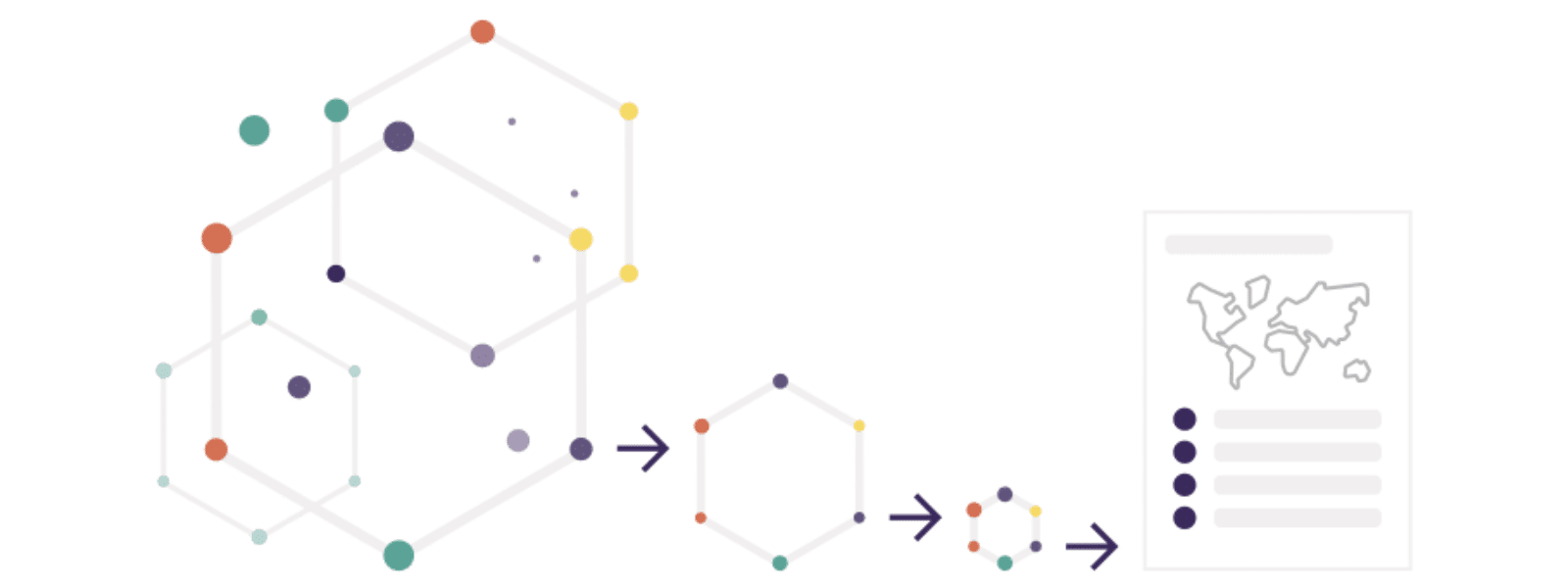
What is CORDIAL?
CORDIAL is a data discovery and access platform that allows users to:
- Find and use Earth observation (EO) data
- Use tools for analysis and visualisation
CORDIAL is provided as a fully managed platform and service accessed via a dedicated web-based app. It requires:
- A standard computer
- A browser
- An internet connection
No software is required to install or setup; users can start accessing Earth observation products in minutes.
Accessing CORDIAL
The environment is configured by the CORDIAL team, who will discuss with you the type of Earth observation data you need. These datasets are then loaded into CORDIAL.
This data can come from a variety of sources, including:
- Freely available open data
- Paid-for services from third parties
- Bespoke datasets developed specifically by PML Applications
For security, access to the platform is limited to authorised users from the client organisation. Users are authenticated using multi-factor authentication, usually with their Microsoft or Google account.
Once logged in, a user has unlimited access to use the data within their CORDIAL subscription and, if necessary, to request additional datasets. The analysis outputs and any intellectual property developed on the CORDIAL platform are entirely owned by the subscribing organisation, so they can be used for any purpose.
CORDIAL also offers the opportunity for organisations to bring their own data to the analysis environment. Since access to CORDIAL is limited to users within a single organisation, it’s possible to host your own data alongside the managed Earth observation data, even if it is commercially sensitive. This offers the unique potential to combine knowledge derived from EO data with your own data in a single analysis environment.
Access world-leading experts in Earth observation at PML Applications and parent company Plymouth Marine Laboratory (PML), who provide advice and guidance, drawing on many years of combined experience and a vast knowledge base.
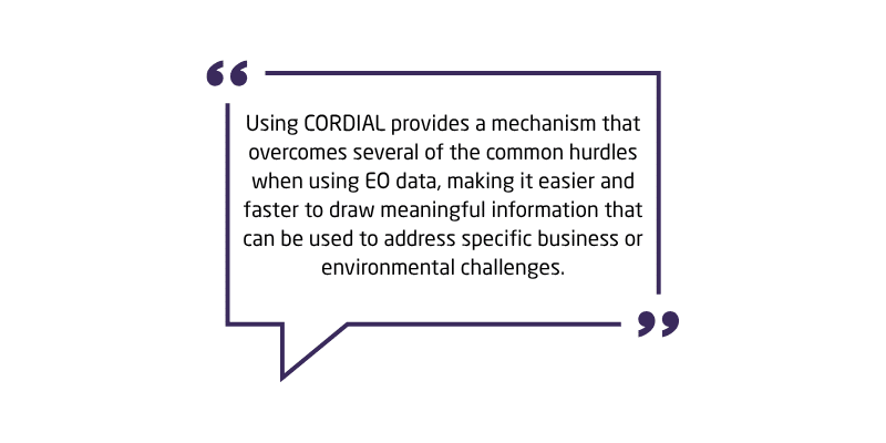
Ben Calton, Head of the Centre for Geospatial Applications at PML Applications, says:
“Anyone can use CORDIAL – we want Earth observation data to be accessible to all. We know it’s a powerful source of actionable information, but making the most of it can be challenging.
Our team understand the benefits and limitations of Earth observation datasets and we understand the impacts of selecting one data source over another. This is a unique service that isn’t routinely provided with similar data analysis platforms, and it means the results produced using CORDIAL will be more specific and meaningful to your needs.
Using CORDIAL provides a mechanism that overcomes several of the common hurdles when using EO data, making it easier and faster to draw meaningful information that can be used to address specific business or environmental challenges.”
Who can use CORDIAL?
CORDIAL is for organisations that do not have the big computing budgets needed to buy specialist equipment. To use CORDIAL, you don’t need to have programmers, data scientists or technical experts who understand Earth observation techniques or data formats. CORDIAL can be used to draw meaningful, useful information that organisations can use for a wide variety of applications.
CORDIAL is aimed at users of varying levels of technical ability:
For GIS analysts, technical specialists, and programmers, it provides a suite of familiar tools in a pre-configured environment, which gives rapid access to large EO datasets without having to download data – a common barrier to EO data use. They can develop analyses in Python with common data science tools, as well as draw on CORDIAL’s built-in algorithm and function libraries.
For anyone who does not want to code and is looking for quick easy-to-read information, whether that be a map, a plot, a table of results, or an infographic, we co-develop analysis applications with a simple-to-use interface that delivers the information they need, as frequently as they need it, with minimal fuss.
CORDIAL In Action
Ben provides three practical examples of how CORDIAL can address specific problems and adds:
“These are by no means the limits of its use. There are many, many more examples, and I am always keen to explore new and innovative potential applications with clients.”
Land Classification Products
Monitor changes to biodiversity using land cover classification products derived from optical and radar satellite data. The applications of this are far-reaching but include:
- Measuring rates of deforestation or afforestation
- The suitability (or otherwise) of habitats within a national landscape, or any other user-defined area, for a particular species to thrive
- Assessing the relative health of important peatlands by monitoring extent, soil moisture, and ground water levels.
Water Quality Monitoring
In water quality monitoring, CORDIAL can analyse land use within a river catchment, specifically, calculating the total area of bare or ploughed fields as a percentage of the total catchment, to use alongside a high-resolution dataset, providing volumetric measurements of suspended matter in sea water.
This helps assess how changes to the percentage of bare soil in a catchment affect surface water runoff lag times and influence suspended sediment levels, in rivers and estuary mouths, near bathing spots following heavy rainfall.
Climate Change Mitigation Projects
There has been significant investment in climate change mitigation projects in recent years. CORDIAL can help deliver evidence to support environmental management plans, to demonstrate that improvements are continuing to work long-term, especially useful in remote or hard-to-reach locations.
Regular and reliable data flows from current and planned satellite missions can provide evidence of a project’s continuing success or provide an early warning of potential pitfalls in a project. For example:
- Afforestation – By monitoring large areas of newly planted trees, regular monitoring can confirm if they are still present and healthy.
- Healthy Seas – Collecting data may demonstrate that sea grass bed extent is growing as a result of changes in marine spatial planning.
In this instance, new data is made available within CORDIAL shortly after acquisition and the analysis can be fully automated.

Subscription Plans For CORDIAL
CORDIAL is available as a subscription service; there’s an initial consultation and setup cost. The price is determined by:
- Volume
- Complexity
- Source of Data
Following an initial consultation, usually a discussion and a planning exercise around the use cases that CORDIAL will help address, we make recommendations about suitable datasets, algorithms, and analysis techniques which will directly address these challenges. The setup cost will be confirmed prior to any commitment to make sure it works for your organisation.
Once in operation, CORDIAL has a monthly subscription fee composed of two elements; a fixed monthly fee which covers all users within a single organisation and provides baseline support, and a variable element, determined by the number of users and their frequency of CORDIAL use – this is a per-user, per-hour charge, so you only pay for what you use.
The Team Behind CORDIAL
CORDIAL in itself is a unique product, and the team behind CORDIAL and the support they provide for a project are equally as uniquely valuable. Ben’s passion for Earth Observation is clear as he talks about developing his expertise in Earth Observation, leading to the creation of CORDIAL:
“There’s something very compelling about looking at the Earth from satellite and being able to understand the processes that affect all our lives on a scale that is much greater than just what I can see, touch, or measure myself. Earth observation data provides the ability to look at the environment on a local, regional, national or even global scale in a way that wasn’t really possible 10-20 years ago.
I joined PML Applications just over 11 years ago, working within the data visualisation team. Coming from a background in commercial software development, I knew very little about Earth Observation when I first joined the company, but have since been involved in major research projects, including ESA’s Climate Change Initiative and the Copernicus Climate Change and Marine services, and have worked with world-class experts who have helped me develop my knowledge. I think I am well placed to support organisations wanting to take their first steps with EO data in achieving their goals, as well as providing guidance to those organisations who already understand the benefits of EO data and want to expand their use of it.
Because there is so much data, it can be daunting to know where to begin, and that was the first challenge that we developed CORDIAL to address – to help clients by directing them to appropriate data that is suitable for their specific objective. Secondly, once you know which data to use, you previously needed an amount of data storage usually measured terabytes, if not petabytes, to download and store it – CORDIAL removes this need. And thirdly, you would need a development environment, along with knowledge of the data formats and the libraries required to interact with the data – CORDIAL provides the environment and greatly simplifies the process of querying, extracting, and analysing data.
We’re operating in a time where there is an ever-increasing number of satellites that can provide insights to big challenges with increasing spatial resolution and more frequent observations, and that’s really exciting. CORDIAL aims to make accessing and using this wealth of information significantly easier and faster.”
Ben heads the team at PML Applications that builds and delivers CORDIAL to a range of sectors. CORDIAL has been developed by PML Applications, a marine consultancy and commercial subsidiary of the marine research charity, Plymouth Marine Laboratory (PML). We have an extensive history and a great track record of producing Earth observation data products covering both marine and terrestrial applications.
Past and current projects at PML and PML Applications include delivering long-time series climate data records to the Copernicus programme, undertaking cutting-edge research for the European Space Agency, and developing software, tools, and algorithms for data production, analysis, and visualisation for national and international clients. Alongside this, work focuses on providing support and guidance to our clients to help them understand their impact on the marine environment, as well as helping them to measure and reduce this impact without adversely affecting their business objectives.
To get started on your Earth Observation project with CORDIAL or to find out more about the capabilities and uses, contact Ben Calton at bac@pml.ac.uk